Real Time Catastrophic Crash Intelligence Guide
Explore Real Time Catastrophic Crash Intelligence: data sources, actionable response, privacy, compliance, costs, and case acquisition for response teams.
Speed alone does not make a crash response more effective. Real Time Catastrophic Crash Intelligence brings timely transportation-incident signals into a usable operational picture, helping response teams assess severe crashes and coordinate decisions while protecting personal information and meeting applicable compliance requirements.
A stream of alerts is not the same as reliable intelligence. Teams need relevant, interpretable information handled with appropriate privacy controls, so they can respond to an incident without exposing more personal data than necessary.
This guide explains how real-time crash intelligence works, which data sources can contribute, and how it differs from traditional incident reporting. It also covers privacy and regulatory considerations, the elements of an effective system, and how crash-related case acquisition fits into the broader picture.
Key Takeaways
- Combine timely incident signals into an operational picture that helps teams prioritize response and coordinate resources.
- Assess how emergency calls and other available signals can contribute to identifying severe crashes.
- Understand the system and implementation factors that shape platform costs, without relying on a one-size-fits-all estimate.
- Distinguish real-time intelligence from traditional reporting by examining how quickly information becomes actionable.
- See how crash-related case acquisition and verification can support plaintiff firms after an incident.
Real-time intelligence for transportation accidents
Transportation crash intelligence combines timely incident signals with location and operational context. The goal is to help response teams assess developing events and direct action using information that is relevant, not merely fast.
Real-Time Crash Intelligence
For a severe crash, a useful operational picture connects the incident location, incoming reports, and response needs. Real-time information can help government agencies and enterprise teams identify where an incident is developing and coordinate personnel, equipment, and recovery resources. Decision-makers should assess whether a system provides actionable updates during active operations, not just delayed summaries.
Washington’s emergency operations centers gained faster access to actionable intelligence, supporting more effective deployment of personnel, equipment, and recovery resources. This example concerns emergency operations broadly, not a crash-only platform. It shows how a shared, current view can support coordination across agencies when transportation incidents affect roads, infrastructure, or nearby communities.
A practical response workflow starts by locating the incident, then combining relevant signals into a common operating picture. Teams can use that view to identify affected areas, prioritize immediate needs, and update decisions as conditions change. Crisis dashboards can alert decision-makers as events unfold instead of hours later, giving teams a more current basis for coordination.
Geospatial context adds an important layer. Washington’s 2025 statewide flood response combined satellite imagery, flood mapping, water-depth estimates, infrastructure information, and operational data from federal, state, and local partners. AI helped identify impacted communities, estimate structural damage risk, and prioritize response activities. In 2026, the initiative received a NASCIO award.
Data Sources and Signals
Severe-crash identification can draw on emergency response signals, including 911 call data used as an input to real-time AI analysis. A system’s value depends on how it connects incoming reports with location and operational context. Teams should examine whether those signals support a clear assessment, rather than treating any single alert as a complete account.
Useful context may also include road and infrastructure information, incident reports, and geospatial layers. Washington’s flood-response model shows how imagery, mapped conditions, infrastructure data, and partner-agency operations can be brought together. For transportation incidents, distinguish information that supports immediate response from personal details that are not needed for the decision.
Earth-observation satellites capture the Earth at meter-level resolution every day, offering one source of geospatial context. Satellite imagery does not replace incident reports or emergency calls. It can, however, help teams interpret conditions around an event, such as access constraints or nearby infrastructure, when relevant to the response.
Before operational use, teams should define how each signal enters the workflow, who can access it, and what decision it supports. For example, an incoming 911 report may flag a possible severe crash, while mapped road information helps responders understand the surrounding area. Keeping these functions distinct makes the information easier to interpret and act on.
Privacy must be designed alongside speed. Organizations handling sensitive crisis data should account for HIPAA and GDPR requirements as applicable to their operations. Limit access to the information each role needs, separate personal details from operational map views where feasible, and set clear controls for sharing data during active response.
What data sources and signals are used to identify severe crashes?
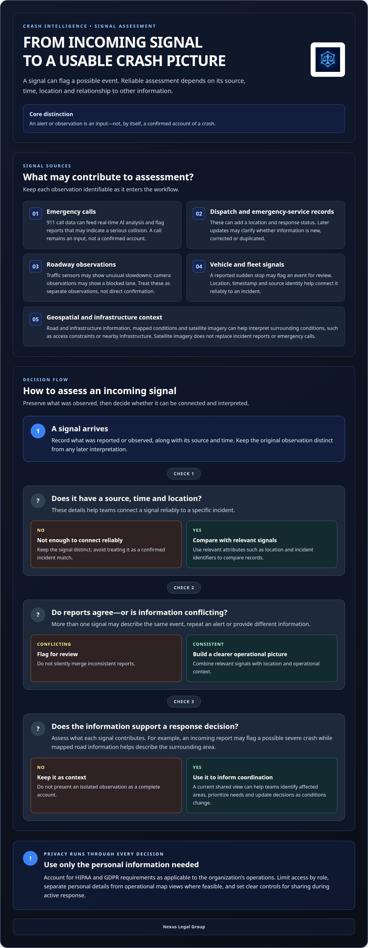
Identifying a severe crash requires combining incident reports with signals that help locate, classify, and assess the event. A useful workflow distinguishes the original observation from later interpretation, so teams can see what was reported and why it was flagged.
Emergency calls provide an early signal. 911 call data can feed real-time AI analysis, helping systems identify reports that may indicate a serious collision. A call is an input, not a confirmed account: operators should distinguish reported facts, such as a location or described hazard, from automated assessments.
Dispatch and emergency-service records can add context as an incident develops. A dispatch record, for example, may connect a reported collision with a location and response status. Comparing it with a later update can help clarify whether the information is new, corrected, or duplicated across systems.
Roadway infrastructure can provide operational context. A traffic sensor may indicate an unusual slowdown, while a camera observation may show a blocked lane. These signals can help explain conditions near a reported crash, but should remain clearly identified as separate observations, not direct confirmation.
Vehicle and fleet signals can offer another perspective when an organization has access to them. A sudden stop reported by a fleet system, for instance, may flag an event for review. Location, timestamp, and source identity are essential: without them, it is difficult to connect a signal reliably to a specific incident.
Data integration should preserve the sequence of events. Record each signal’s source and time, then match records using relevant attributes such as location and incident identifiers. Flag conflicting information for review rather than silently merging inconsistent reports. This helps distinguish a crash from nearby events or repeated alerts.
Assessing severity also requires careful interpretation. A report of a lane obstruction, an emergency-response record, and a traffic slowdown may together indicate a disruptive event. Their combination can prioritize review, while keeping each source visible so responders can evaluate the evidence behind the classification.
Signal quality depends on freshness, location accuracy, completeness, and clear provenance. A precise timestamp can help distinguish an active event from an older report, while an imprecise location can complicate matching. For every source, define what it contributes, who can access it, and how corrections and duplicates are handled.
Limit personal information to what the operational task requires. A response view, for example, may need an incident’s location and status without displaying unrelated identifying details. Clear access roles and data-handling procedures help teams use crash signals while protecting information during intake and analysis.
For organizations connecting emergency-service information with crash-related case workflows, structured MVA incident information can support a more organized transition from initial signal to case review.
Retain enough context for each source to explain what it represents and how it relates to the event under review. A signal does not become more certain simply because it appears alongside other records. Keep observations distinct, note conflicts, and clarify which details are reported evidence and which are interpretation. This matters when information helps prioritize a response: the combined picture can direct attention without obscuring uncertainty or the origin of each observation.
Washington established a framework intended to support future wildfires, landslides, severe weather events, and infrastructure emergencies. Such a framework can be considered alongside incident-level signals, while keeping its role distinct from evidence about a particular crash. The flood data shown for Hurricane Ian includes flood depths greater than 2 metres. That information can illustrate why environmental data should retain its stated measure and context when presented with other signals. It should not be recast as a direct observation of a crash, or used to imply a connection that the available information does not establish. Clear separation between event records, environmental context, and subsequent assessment helps users understand what the data supports and where interpretation begins.
What are the costs of real-time crash intelligence platforms?
There is no single price for every crash intelligence platform. The total depends on data sources, integration requirements, operating scope, and support model. A transportation agency connecting one incident feed has different needs from an enterprise coordinating data across multiple jurisdictions.
Price depends on the case and is provided after a quote request. Key cost factors include data access, system integration, user requirements, security controls, and ongoing support. Separating these elements helps decision-makers understand what a proposal covers and which capabilities drive its total.
Start by defining the operational use. A city team focused on roadway response may need incident alerts, mapped locations, and a shared dashboard. A regional emergency operation may require information from several agencies, additional geospatial layers, and resource-coordination workflows. These different scopes affect implementation and ongoing system demands.
Data access is another major consideration. A platform may connect emergency-service reports, traffic information, infrastructure records, or other inputs. Each source brings different access arrangements, data formats, update patterns, and quality-control needs. Integrating a structured incident feed, for example, differs from reconciling reports received in varied formats.
Integration work can also shape the overall investment. Existing dispatch, traffic-management, or emergency-operation systems may use different interfaces and data structures. A project must account for mapping fields, resolving duplicate records, testing information flows, and determining how updates reach users. The number and complexity of these connections matter more than a feature label alone.
Teams should assess the following cost components separately:
- Data inputs: Which incident, roadway, or geospatial sources are included, and how are they accessed?
- Implementation: What configuration, interface work, and testing are required for existing systems?
- Usage: How many operational teams need access, and what functions does each role require?
- Governance: What access controls, retention practices, and review processes apply to sensitive information?
- Ongoing operations: Which maintenance, support, and workflow updates are included over time?
Scope security and privacy requirements early rather than treating them as later additions. A response dashboard, for example, may show incident location and status while restricting access to identifying details. The design, access roles, and handling procedures all influence implementation work and operational responsibilities.
Compare proposals by matching each cost component to a defined use case. Ask whether the quoted scope includes data connections, deployment, user setup, training, maintenance, and future changes. If proposals describe different inputs or workflows, their totals are not directly comparable.
Begin with a written scope: identify the response decisions the platform must support, list the required data sources, and document existing systems to integrate. Then separate initial implementation costs from ongoing operating costs. This gives agencies and enterprises a consistent basis for assessing value without relying on an unsupported industry-wide average.
A proposal is easier to assess when its cost is tied to the operational problem it is meant to address. Before comparing options, describe the response decisions the platform should support and the information users need. Ask vendors to separate setup, data access, integration, and ongoing support instead of relying on a single total. This helps reveal whether a lower initial quote leaves important work or continuing services outside its scope. It also gives teams a basis for evaluating changes as requirements evolve.
The National Institute of Building Sciences states that each $1 invested in mitigation saves an average of $13 in future disaster costs. That benchmark concerns mitigation broadly; it is not a guaranteed return from a crash intelligence platform or a platform-specific estimate. Agencies should therefore avoid treating it as a direct price comparison. Instead, they can consider how the proposed capabilities relate to their own response objectives, what costs are included, and how they will review whether the system is useful in practice. Clear assumptions about scope, service, and expected use can help decision-makers judge a proposal without confusing potential wider benefits with a guaranteed financial saving.
How do crash intelligence systems compare with traditional traffic incident reporting?
Traditional incident reporting documents an event through reports compiled after information is collected. Crash intelligence systems connect incoming signals with operational context as events develop. The difference is timing and use: a completed report supports review, while a current incident picture can inform active response decisions.
In a conventional workflow, an agency may receive reports through separate channels, record incident details, and prepare summaries for later review. A traffic report, for example, may describe a blocked road after personnel have gathered the relevant information. The record can support documentation, but may not reflect conditions that changed after the initial observation.
A real-time system brings available updates into a shared view, helping authorized users assess the current situation. Connecting a road closure, emergency report, and infrastructure update at the same location can help teams understand operational impact. The system should preserve each source’s identity and timing rather than presenting every signal as a verified fact.
Washington provides a clear example of faster processing. The state completed analysis that had historically taken weeks of manual work in hours or days. This shows how data integration and automated analysis can shorten the path from separate information to usable findings, while human teams still interpret results and decide what to do.
Comparing these approaches requires more than asking which is faster. Review how each handles the following operational requirements:
- Timing: Does the information arrive during active response or after report preparation?
- Context: Can users relate an incident to nearby roads, infrastructure, and response activity?
- Traceability: Can teams identify the source and timing behind an alert or summary?
- Corrections: Can an updated report clarify or replace an earlier description without obscuring the history?
- Use: Does the output support a response decision, later analysis, or both?
These approaches serve different stages of operations. A real-time view can help a transportation team coordinate an immediate response, while a formal incident report preserves details for later review. Neither eliminates the need for the other. A sound process connects current operational information with the records used for subsequent analysis.
Speed also increases the need for oversight. An automated alert, for example, may surface a developing incident, but staff need to distinguish the alert from confirmed information. Clear access controls matter when a dashboard combines operational updates with sensitive details. Define which roles need each information category and how corrections are presented to users.
For plaintiff firms, the distinction matters after response activity produces formal crash documentation. Police-report-generated MVA leads connect case acquisition to report-based information, rather than treating a real-time alert as a substitute for an accident report. The right workflow depends on whether the immediate need is response coordination, later incident review, or case acquisition.
Use police report generated MVA leads
Nexus Legal Group
Nexus Legal Group supports plaintiff firms seeking a structured workflow for crash-related case acquisition. Its High-Intent MVA Case Acquisition combines Police Report Generated MVA Leads and Emergency Services Generated MVA Leads with Automated Verification. These services help firms identify and assess potential motor vehicle accident cases once incident information becomes available.
For firms building a process around emergency-service or police-report signals, this approach connects relevant lead sources with intake verification. It complements transportation intelligence; it does not replace emergency response systems or incident reporting.
Contact Nexus Legal Group to discuss MVA case acquisition.
Turn Incident Insight Into a Clear Next Step
Real Time Catastrophic Crash Intelligence can help organizations interpret developing transportation incidents, while plaintiff firms also need a defined process for evaluating potential cases. The next step is to connect relevant crash information with a focused acquisition and intake workflow, keeping response intelligence distinct from case-development tools.
Nexus Legal Group supports this workflow through High-Intent MVA Case Acquisition, Police Report Generated MVA Leads, and Automated Verification. These services suit plaintiff firms developing MVA case acquisition and seeking report-based leads with verification built into the process.
Choose a next step that aligns with your firm’s intake priorities and the information sources you use. A structured workflow can help your team move from incident signals to organized case review.
With the right workflow, your team can move forward with greater clarity and focus.
Frequently Asked Questions
What does real-time catastrophic crash intelligence mean?
It means turning developing crash-related information into an operational picture that supports timely decisions. If emergency call reports describe a collision near an interchange, for example, a system can associate the reports with a location and flag the event for review. The term describes an information and decision-support process, not a guarantee that every crash will be detected or independently confirmed immediately.
What technologies detect and report catastrophic crashes in real time?
These systems can use emergency-call intake, AI-assisted analysis, geospatial software, and dashboards to organize incoming information. For example, analysis software could flag a 911 report that describes multiple vehicles and a blocked roadway, then display its reported location for review. The specific inputs vary by deployment; the useful design question is how each technology supports a decision and makes the underlying signal understandable to authorized users.
What privacy, cybersecurity, and data-sharing risks do these systems involve?
Risks include exposing personal details, granting broader access than a role requires, or sharing information beyond its operational purpose. Incorrectly linking a caller’s details to the wrong incident can also affect later decisions. Organizations can reduce these risks by limiting access, protecting data during transfer and storage, logging record access, and defining which partners receive which fields. Clear correction procedures help address errors before information spreads.